Get us in your inbox

Search
Regional Connector
Photograph: Time Out/Michael JulianoAudrey Chan, ‘Will Power Allegory’ at the Little Tokyo/Arts District Station

A beginner’s guide to Metro in L.A.

Everything you need to know about TAP cards, subway lines, buses and more

Michael Juliano
Written by
Michael Juliano
Advertising

Some Angelenos don’t realize that there’s a subway rumbling underneath their feet—or maybe they just choose to ignore it. The truth is, you can navigate large parts of Los Angeles without ever stepping foot in a car thanks to Metro. 

People like to complain about L.A.’s supposedly paltry public transit offerings almost as much as they fume about traffic—which, you know, maybe explains the traffic. Look, Metro isn’t perfect: Light rail service can be slow, most bus routes sit in the same rush hour traffic as cars and many of us are still miles from the nearest subway station. But at its best, L.A.’s transit system should be a point of pride: Underground, some of the B Line stations and new Regional Connector stops are practically works of art, while aboveground you can watch as light rail lines whiz past rush hour traffic.

Whether you’re visiting for the first time or fed up with your daily commute, use our beginner’s guide to the Los Angeles Metro to start your car-free adventure around the city.

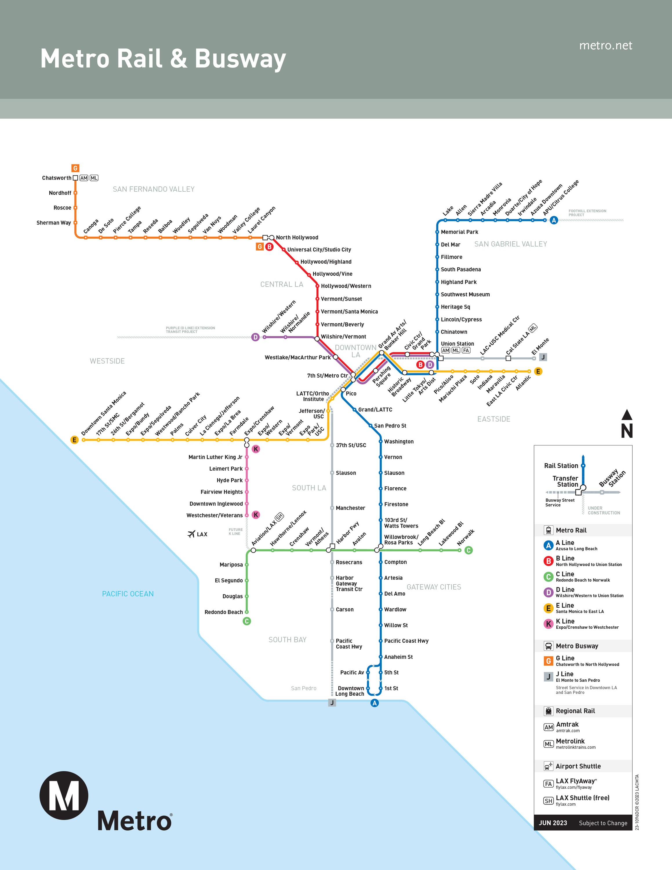
Riding (and paying for) Metro

The first thing you’ll need before boarding a train or a bus is a physical or digital TAP card. Though we’re all for technology, we’ll actually start with (and recommend) the physical TAP card: Available at all Metro Rail stations and select retailers with a $2 surcharge, these reusable cards can be filled with pre-set dollar amounts. A single ride, regardless of the destination, costs $1.75 and includes free transfers for up to two hours.

As of July 1, 2023, Metro’s fare-capping structure eliminates daily, weekly and monthly passes with set dollar amounts in favor of a maximum amount that you’ll be charged (as long as you’re using a TAP card): $5 a day or $18 a week.

Very few bus stops have TAP vending machines, but you can buy a new card on board (buses also accept exact change). Make sure to hold onto your card as it’s accepted on all 26 county transit agencies (and has a 10-year lifespan). You can also order or refill a card on the TAP website.

So what about that digital version? Available as an app for both iOS and Android, TAP L.A. lets you use your smartphone to pay for your Metro ride. While it’s kind of magic, we’ve had enough finicky experiences that we don’t necessarily recommend it for first-time riders.  

When you’re entering a train station or a bus, it’s as simple as holding your TAP card against the marked terminals. Some light rail stations don’t have turnstiles, but still make sure to tap—otherwise you could face up to a $250 fine. 

Most lines operate from before 5am to after midnight. Trains run as often as every 10 minutes during peak times, though you could be stuck waiting for 20 minutes during late nights. Use Metro’s Nextrip service to take out some of the arrival time guesswork.

Metro Rail

Heavy Rail (Subways)
Photograph: Courtesy Steve Hymon/Metro

Heavy Rail (Subways)

There are only two subway lines in L.A., one of which shares most of its stops with the other. Underground heavy rail is admittedly not our strong point—blame it on fault lines and politics.

Though the original lines were named after colors (with the exception of the Expo Line), Metro has since renamed each line after letters instead.

B Line (Red)

Metro’s original subway line starts at Union Station, with additional stops near Downtown landmarks like Grand Park, the Music Center and Grand Central Market. It continues toward Hollywood, where it makes a stop by the Pantages Theatre, the Walk of Fame and Ovation Hollywood (where you can catch a shuttle to the Hollywood Bowl), before stopping across the street from Universal Studios and in North Hollywood by the NoHo Arts District.

D Line (Purple)

This stub of a subway line shares the B Line track until Wilshire/Vermont, where it forks and ends with two stops in Koreatown. Within the next decade, service will expand west to reach LACMA (by 2025), Beverly Hills (2026) and UCLA (2027).

Thanks to the new Regional Connector Project—more on that in a minute—these two subway lines now more seamlessly link up with some of the light rail lines below, specifically at the 7th St/Metro Center station.

Light Rail
Photograph: Courtesy Steve Hymon/Metro

Light Rail

These (mostly) above ground lines sometimes have dedicated rights-of-way or signal priority but often share the road with cars. They’re not as fast as underground subway lines, especially as they travel through residential neighborhoods. That said, they’re still an efficient, sometimes scenic car-free option.

They’ve also been radically transformed by the new Regional Connector. Just three new stations along a 1.9-mile stretch of tunnels in Downtown L.A. have streamlined three shorter routes (A, E, L) into two longer ones (A, E) and made transfers much easier—knocking as much as 20 minutes off some rail commutes.

A Line (Blue/Gold)

The southern half of this line, the very first Metro line built, loops around Long Beach, heads up through South L.A. (including a stop near Watts Towers) and into Downtown.

Now, thanks to the Regional Connector, it also continues onward into Union Station and—along the former Gold/L route—through ChinatownHighland Park, South Pasadena and Pasadena, where the line has six stations. From there, it ventures deeper into the San Gabriel Valley, with stops between Arcadia and Azusa. Grab a window seat for fantastic views of the San Gabriel Mountains.

In the middle of DTLA, the A Line shares three underground stops (the Regional Connector ones) with the E, including one directly behind the Broad and another about a block up from Grand Central Market.

Put it all together and you have what Metro says is the longest light rail in the world. Its southern expanse though, originally the Blue Line, has some more unfortunate distinctions: crime and car-on-train wrecks (though a series of rolling station closures in 2019 worked toward addressing these issues).

C Line (Green)

This line runs in the middle of the 105 freeway from Norwalk to the inland South Bay, including a stop that’s sort of close to LAX—you’ll have to transfer to a shuttle bus to get to the airport.

E Line (Expo/Gold)

One of Metro’s newer light rail lines stops only blocks from the beach in downtown Santa Monica. From there, it moves east into downtown Culver City, makes stops across from USC and Exposition Park and veers just a few blocks from the Crypto.com Arena (a stop it shares with the A Line).

Though it initially terminated on the western edge of DTLA, it now follows the eastern segment of the former Gold/L line and continues into Little Tokyo and the Arts District before wrapping up in East Los Angeles, with a stop at Mariachi Plaza in between

The mostly at-grade line is a little slow getting into and out of the western edge of DTLA, as it rarely has signal priority, but it’s at least a headache-free alternative to driving.

K Line (Crenshaw)

The system’s newest light rail line will include a stop just outside LAX—but not quite yet. The K Line currently runs from the E Line’s Expo/Crenshaw stop near West Adams and Leimert Park, through Inglewood and to Westchester/Veterans stop. Eventually it’ll connect with the C Line at Aviation/LAX, but until then a bus will run on the southern end. In late 2024 (hopefully), the LAX/Metro Transit Center Station will open—that’s where the line will link up with LAX’s Automated People Mover in 2025.

Buses and more

Metro Bus
Photograph: Courtesy Steve Hymon/Metro

Metro Bus

There are two Metro Liner routes. These extra-long buses have dedicated lanes on the freeways and surface streets. Think of them like rail cars, just smaller and with less frequent service.

G Line (Orange)

This Valley-serving route runs from the North Hollywood B Line station to Chatsworth.

J Line (Silver)

You’ll find these buses sharing the toll lanes on the 10 freeway starting in El Monte, with stops at Union Station and Downtown L.A., before turning south along the 110 freeway, with stops at USC and South L.A. before ending in the industrial Harbor Gateway.

In addition, Metro has a far-reaching bus system that is broken up into two main types: Local and Rapid. The orange local buses cover much of Los Angeles and its satellite cities. The red Rapid lines have fewer stops and more frequent service.

Of special note: the Dodger Stadium Express. This free service to Dodger Stadium leaves from Union Station on game days and whizzes by the traffic back-up on Sunset Boulevard—the return ride isn’t quite so traffic-free.

Metro Micro
Photograph: Courtesy Metro Micro

Metro Micro

What if you could summon a shared Uber to nearly anywhere within your neighborhood for only a couple of dollars? That’s basically the premise behind Metro Micro, and it’s kind of magical (though sometimes you need to plan a little in advance).

Here’s the deal: Using the Metro Micro app (or calling 323-GO-METRO) you can hail a shared ride in a 10-person van as long as you’re within one of its operating zones. No matter how far you go within that zone, the trip is only $2.50 (that’s just recently increased from only $1, though if you use your TAP card the fare now includes free transfers to Metro bus and rail, or a 75-cent Metro Micro transfer from a Metro bus or rail line).

Metro Micro currently operates in Watts and Compton; Inglewood and near LAX; North Hollywood and Burbank; El Monte; Altadena, Pasadena and Sierra Madre; the Northwest San Fernando Valley; Westwood (including UCLA); and Highland Park, Eagle Rock, Glendale and Silver Lake (a serious gamechanger for getting around Northeast L.A.).

The hours vary by area, but service runs as early as 5am and until as late as 10pm. It’s not exactly point-to-point: If you book a ride, the app will likely pair your pickup and dropoff spots to their closest bus stops.

We’ve used Metro Micro a number of times, and though it’s not perfect, we found the experience largely positive. We’ve had rides come nearly immedaitely and just across the street from our starting point, while other times we’ve waited 15 minutes or more and had to walk a block and a half; you might also find the service is too busy to secure a van during rush hour, so consider pre-scheduling a ride if you can. 

Advertising

Other transit systems

Many other city-specific bus lines run in addition to Metro, among them Santa Monica’s Big Blue Bus, LADOT’s Dash network and the San Gabriel Valley’s Foothill Transit. The good news? Your TAP card will work on those systems along with dozens of others.

For longer distances, there’s also the Metrolink commuter rail system. Most lines originate at Union Station and cover destinations as far out as San Bernardino, Lancaster, Orange County, East Ventura and Oceanside. Metrolink doesn’t accept TAP cards, but they do sell TAP-enabled and digital tickets for Metro transfers (in fact, you can transfer to the Metro for free with your activated Metrolink ticket). Metrolink service can be frighteningly infrequent, so don’t waste time searching for a ticket machine before your train departs and instead buy a digital ticket through Metrolink’s app.

I have some questions…

Why does our public transit system suck?

Well, you know, that’s just like, your opinion, man. A ride on the B Line between Hollywood and Downtown is almost always more efficient than driving on the 101. And it’s cheaper than transit systems in any other metropolitan area of our size.

Metro doesn’t go anywhere, though.

Most of L.A.’s major city centers—Downtown, Hollywood, Koreatown, Culver City, Long Beach, Pasadena and Santa Monica—are linked up by Metro service. We’ll admit, though, that some of the rails lines have a bit of a last mile problem; the stops often aren’t quite where you wish they were, which for many riders means a hefty walk, connecting to a bus or using a ride-hailing app. The rollout of bike and scooter rental apps has helped alleviate the issue, as has Metro Micro in some areas.

But nobody rides it!

It’s true that ridership declined for a couple of years—as has been the case in many other cities—though numbers have begun to rebound over the past year. But it’s also one of the largest public transit systems in the country by ridership, particularly its lengthy light rail lines and considerably-sized bus fleet. People ride it.

I saw Collateral (decade-old spoilers)—there’s no way those trains are safe.

As you would on public transit in any major city, keep your wits about you—that particularly includes not waving your phone around if you’re sitting or standing by the doors. It’s true that the number of reported incidents has increased over the past couple of years, but the number of crimes is still relatively small.

Didn’t L.A. used to have an amazing transit system and then the evil automobile companies screwed it over?

The Pacific Electric Red Car system stretched all over Southern California until it was torn up by the evil auto companies—according to the plot of Who Framed Roger Rabbit? The reality is more nuanced than that. Yes, the street car lines were bought out and eventually decommissioned, but they were also already in decline as L.A. spiraled into an automobile-driven sprawl. 99% Invisible has a great primer on the whole conspiracy, as does the L.A. Times.

Recommended

    More on green cities

      You may also like
      You may also like
      Advertising