[category]
[title]
The United Nations has backed a move towards maps that more accurately represent the true size of continents, in a major symbolic win for Africa.

164 votes to 1.
That was the overwhelming response from countries across the world to finally acknowledge Africa’s rightful depiction on the global map.
Since the 16th century, the Mercator projection has been used to depict continent sizes on world maps, with Africa appearing significantly smaller in comparison to other continents – despite its actual size.
It was only the United States of America that voted against the Equal Earth Project, while Estonia, Georgia, Lithuania, Moldova, Serbia, and Ukraine all abstained from the UN General Assembly vote on 4 September 2026.
But behind what might sound like a niche cartography debate is a much bigger question: how has the map we have grown up with shaped the way we see the world?
READ: South Africa gets top honours at World Travel Awards Africa 2026
The Mercator projection dates back to 1569, when Flemish cartographer Gerardus Mercator developed it to solve a very practical problem of the time: navigation.
For sailors, the projection was revolutionary. Straight lines on the map represented constant compass directions, allowing navigators to plot courses across the oceans more easily.
There was, however, a significant trade-off.
The projection preserves direction but distorts the size of landmasses. The further a place is from the Equator, the more exaggerated its apparent size becomes.
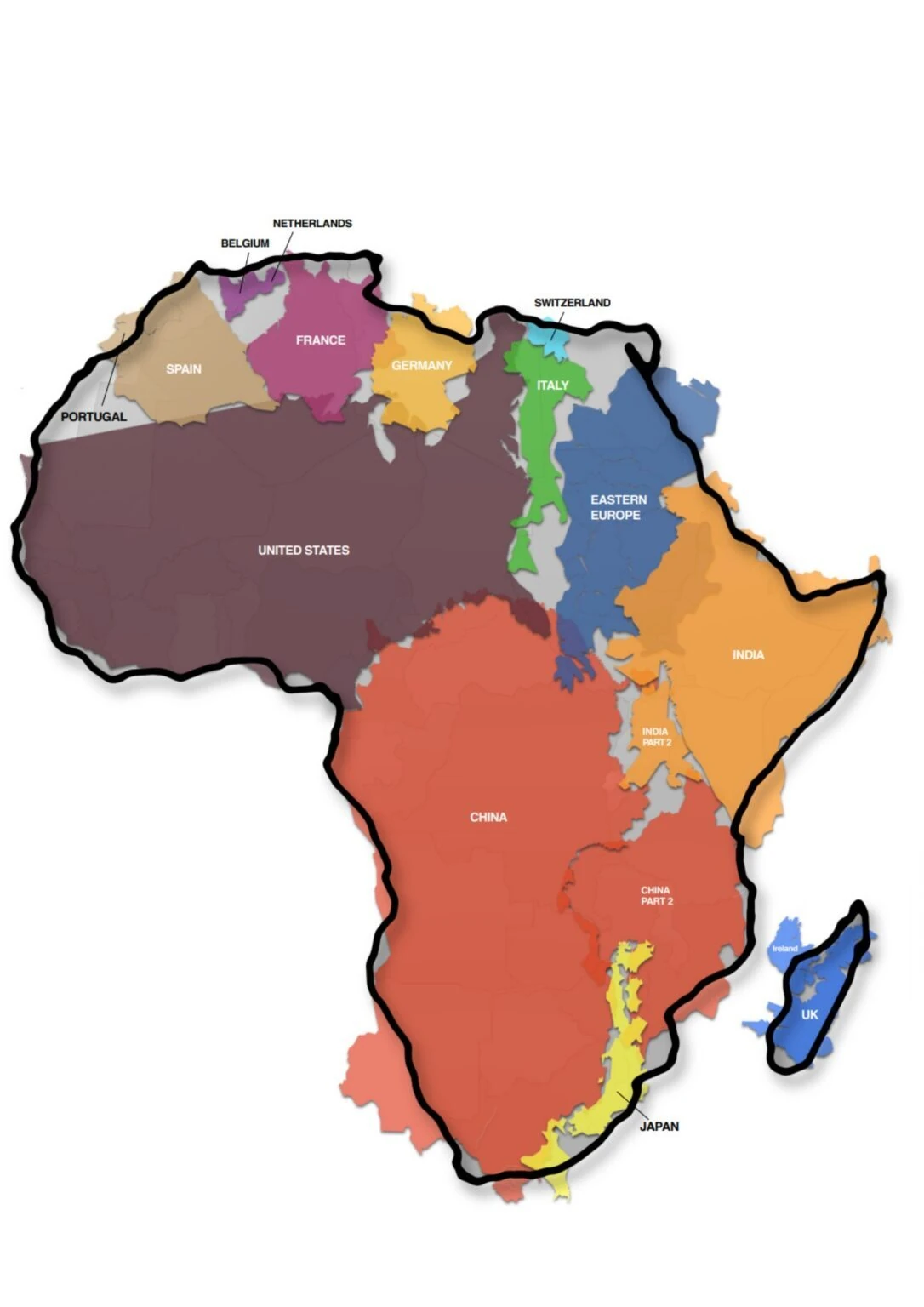
This means Greenland can appear to be roughly comparable in size to Africa on a conventional Mercator map. In reality, Africa is about 14 times larger than Greenland.
Northern Europe, Russia, Canada and other regions at higher latitudes are similarly enlarged, while areas around the Equator appear disproportionately smaller.
And although Mercator was created primarily for maritime navigation, its influence spread far beyond the sea.
This map is a familiar fixture in classrooms, textbooks, media, digital platforms, and official materials, which means generations of people have grown up seeing a distorted version of the world's relative geography.
This is a mathematical challenge of turning a three-dimensional globe into a two-dimensional map. No world map is completely distortion-free. When you flatten a sphere, something has to give – whether that is area, shape, distance, or direction.
Mercator prioritises direction, making it particularly useful for navigation. The problem comes when the projection is used for purposes where relative size matters.
On a Mercator map, continents closer to the poles become increasingly stretched. Africa, most of which lies closer to the Equator, looks much smaller than it actually is compared to northern landmasses.
Africa is the world's second-largest continent by land area, stretching across more than 30 million square kilometres and encompassing 54 countries, hugely diverse landscapes, cultures and communities.
According to the online campaign group #CorrectTheMap: "You could fit the United States, China, India, Japan, Mexico and much of Europe into Africa and still have land to spare.”
The distortion has prompted a much broader debate about whether the world's most familiar map has also contributed to how people perceive different parts of the planet.
As the United Nations reported, the resolution points to the way these distortions have contributed to the ‘symbolic minimisation’ of Africa and perpetuated an unbalanced view of the world.
The push for change has been led by Togo, negotiating on behalf of the African group and building on a campaign backed by the African Union.
The campaign acknowledges the projection's enormous historical importance and usefulness for navigation but argues that different maps should be used for different purposes.
One alternative is Equal Earth.
This projection was developed in 2018 to provide a more accurate visual comparison of land areas on the world map.
Togo's Foreign Minister Robert Dussey summed up the wider argument ahead of the vote, saying: “Maps shape our understanding of the world. They guide education, nourish the imagination, and influence collective perceptions. A fair map does not change the geography of the world; it changes how we see the world.”
The resolution itself describes correcting historical distortions as an act of ‘cognitive justice and memorial reparation’.
The UN resolution is non-binding, which means it doesn't prescribe one replacement for the projection. Mercator remains useful for navigation and will continue to have a place in cartography.
The resolution encourages governments, schools, international organisations, and tech companies to consider equal-area maps when showing the relative size of continents and countries. It also calls for greater education around the fact that every flat world map involves some form of distortion.
For Africa, however, the significance is more than cartographic accuracy. What is changing is the visual representation that generations of people have encountered since childhood.
This just shows how important it is to question everything. Even those accepted resources you were given in school!
Sign up to Time Out South Africa's free newsletter for expert recommendations on new things to do, see, eat and drink in the country.
TIME OUT SOUTH AFRICA RECOMMENDS:
📍 The best things to do in Pretoria
📍 The best things to do in Durban
📍 The best things to do in Johannesburg
📍 The best things to do in Cape Town
Discover Time Out original video