[category]
[title]
Frigid temps and snow are expected across the Southeast and New England in the next few days.


Heads up: some of you may want to put your plans on hold this weekend because a powerful bomb cyclone is on track to slam parts of the U.S. Forecasters warn that this rapidly intensifying storm could bring heavy snow to the Southeast, dangerous winds along the East Coast and coastal flooding from North Carolina all the way to New England.
The storm is expected to strengthen quickly as it forms near the Southeast coast late Friday and heads north through Saturday and Sunday. Bitter Arctic air already locked over much of the eastern half of the country will help fuel the system, turning what might have been a cold rain into snow.
Even sunny Florida is expected to experience freezing temperatures, which is very bad news for citrus crops. Cities in Louisiana, Mississippi and Tennessee have already taken a hit, with widespread power outages. Freezing temperatures are expected to return to these areas.
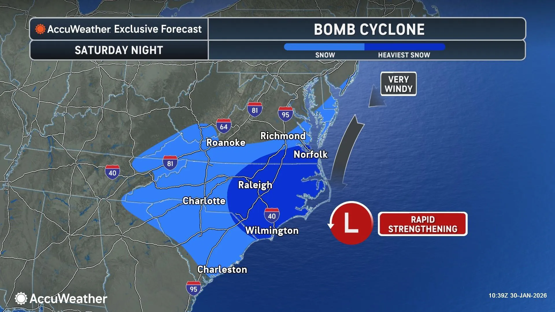
“This storm could unleash heavy snow and howling winds across the Southeast this weekend. People need to prepare for the possibility of dangerous blizzard conditions in some coastal areas from North Carolina to the southern Jersey shore. Blizzard conditions may reach parts of Long Island and southern New England,” AccuWeather senior meteorologist Scott Homan said.
North Carolina and southern Virginia are likely to see several inches of snow. Cities like Charlotte and Raleigh could experience one of their most disruptive snow events in decades. As the storm tracks north, parts of coastal New Jersey, Long Island and southern New England could pick up anywhere from 3 to 12 inches of snow, depending on how close the storm stays to shore.
Strong winds will be a major factor. Gusts could reduce visibility to near zero during heavier snow bands, making travel extremely dangerous. Coastal flooding is also a concern, especially around high tide. With a full moon enhancing tides, water levels could rise 2 to 4 feet above normal in vulnerable coastal communities.
Air travel will likely take a hit, with AccuWeather experts saying more than 5,000 of flight cancellations are possible from Saturday through Monday. Power outages are also a concern, especially in areas already weakened by recent ice and snow. Here's what you need to know about this weekend's forecast.
A bomb cyclone is a storm that strengthens extremely fast. It happens when air pressure drops at least 24 millibars in 24 hours or less. Two fronts of warm and cold air move against each other and begin to rotate around a low pressure center. A bomb cyclone can be described as a winter hurricane.
The storm is forecast to develop near the Southeast coast, bringing heavy snow to parts of North Carolina and Virginia before pushing north along the East Coast. Coastal areas from the Carolinas to New England could see snow, strong winds and flooding, with impacts varying based on the storm’s exact path.
Avoid unnecessary travel during the height of the storm. If you lose power, have flashlights, batteries and warm clothing ready. Stay clear of coastal areas during high tide, and keep an eye on local forecasts as conditions can change quickly.
Discover Time Out original video