[category]
[title]
Everyone who calls Chicago home ought to make an effort to make the city a better place. Whether it's volunteering or giving impeccable instructions to naive tourists, it's important to give back to the town that gives you a bounty of amazing cocktails and wet beef sandwiches. But in order to be a great Chicagoan, it's important to be educated on both the history and current state of the city. Use these nine maps as a springboard for getting to know Chicago a bit more intimately (or at least as great trivia fodder).

In its early days, Chicago looked nothing like it does today. This map from 1857 paints a picture of the city that feels alien to anyone strutting about town in 2015. For starters, the town's population was just 110,000, and it contained just 11 public schools. Lincoln Avenue was called "Little Fort Road," Lincoln Park was a massive cemetery, Blue Island Avenue was called "Hoosier Street" and Union Park was, well, in its current location.
This map was made 14 years before the Great Chicago Fire and 36 years before the World's Fair, which were two events that greatly changed the way the city looks today.

It's hard to imagine Chicago without its interstate system, but before automobiles and suburban living caught on, locals traveled primarily by way of streetcar. Imagine hopping on the 4 instead of the Red Line to catch a Cubs game at Wrigley Field, or commuting to class at "De Paul University" on the 8.
After World War II, families started flowing into the suburbs, and in 1956 President Dwight Eisenhower passed the Federal-Aid Highway Act that brought a massive interstate system to Chicago. At that point, streetcars became all but obsolete.
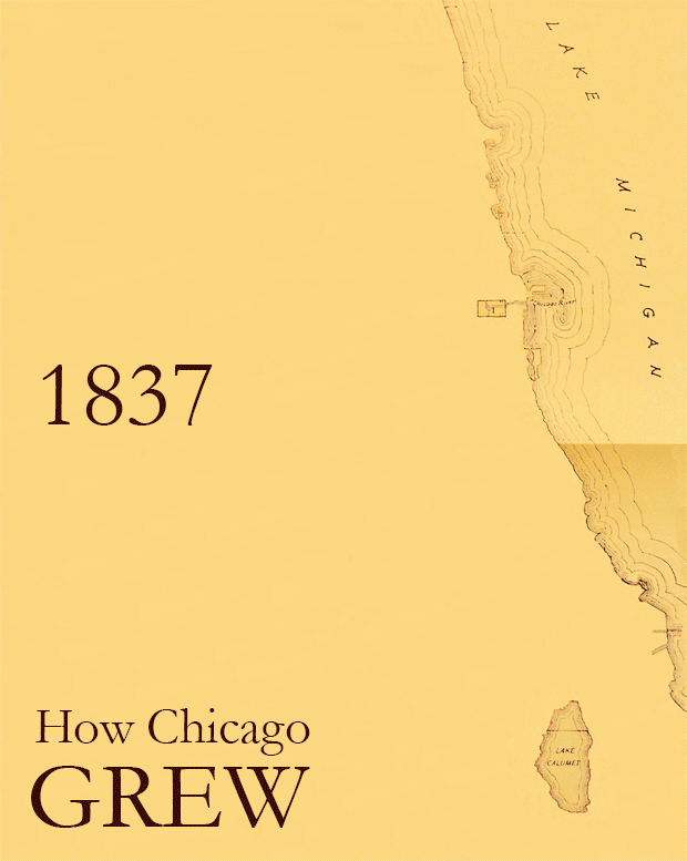
Gif via Curious City: How Chicago gobbled its neighbors.
Chicago didn't always occupy the 237 square miles of land that it does today. When it was founded in 1837, the city's borders were Lake Michigan to the east, North Avenue to the north (get it?), 22nd Street to the south and Wood Street to the west. In 1889, the city annexed the townships of Hyde Park, Lake View, Lake and Jefferson. With those additions, Chicago's population swelled to more than one million, giving it the "metropolis" status it needed to bring the World's Fair to the city four years later.

Chicago is known as the city of neighborhoods, the boundaries of which are pretty ambiguous. In 1978, the city's Department of Planning conducted a survey asking residents the name and boundaries of their respective neighborhoods. The above graphic shows the results of that survey, which would probably be contentious today (especially considering that a lot of residents consider North Avenue to be the border between Wicker Park and Bucktown, and not Armitage Avenue).
Unlike neighborhoods, Chicago's community areas have official, static boundaries. Originally set in the 1920s by a research committee at the University of Chicago, the city's 77 community areas are tied to the census and other data collection initiatives. Wicker Park, Pilsen and River North aren't community areas, but only neighborhoods, which explains why everyone gets all up in arms about the boundaries of each.
Crime in Chicago catches a lot of headlines, but the city is all too often depicted as a dangerous, godless place where everyone is harming one another on a regular basis. The map above breaks down violent crime incidents (excluding homicides) by police beat. The areas with the highest rates of violence are those that often get a lot of coverage for such: the South and West sides. But there are plenty of beats in both of those areas that were less violent in 2014 than the beat that borders Wrigley Field to the south, so cool it with the stigma, people.
Chicago has a lot of rats, and (luckily?) the city's data portal keeps track of 311 service requests for rodent baiting. According to their data set, more than 41,000 premises across the city were baited for rats from the start of 2015 through the end of September. Not surprisingly, the five community areas with the most premises baited during that stretch were all on the North Side.
Chicago has caught a lot of flack about its speed and red light camera programs. The pesky intersections have been plaguing drivers across the city with expensive fines for more than a decade. Even though the red light program was proved to be ripe with corruption, Mayor Rahm Emanuel's administration is still depending on the cameras to bring some much needed revenue to a city that's facing one of the biggest pension crises in the history of the country.
The map above shows the locations of every speed and red light camera across town. Be cautious at these intersections (or avoid them altogether).

Last year, Chicagoist dug into the data portal for crime incidents that took place in bars to determine the boundaries of the city's "Douche Vortex." We repeated their process for the first 10 months of 2015 and, to no surprise, the hot beds of such incidents were in River North, Wicker Park, Wrigleyville and the Viagra Triangle. If you want to be the best Chicagoan you can be, avoid bars in these areas at all costs (or at least stop contributing to arrests made there).
Discover Time Out original video